
The short answer: Google plans at most 25 stops per route request, the start and the destination included. To plan a longer route you split the list into legs of 25 that join end to end. RouteTally, a Google Sheets add-on, does that splitting for you: put up to 100 addresses in a column, click Run, and get one table with a total and a Google Maps link for each batch.
Why a long route stops at 25 stops
When a spreadsheet asks Google for a route, it sends one request, and one request can hold a start, a destination and up to 23 stops in between. A 40-stop delivery list does not fit. Neither does a field rep’s week of 60 client visits.
The manual way, and where it goes wrong
You can get around the limit by hand:
- Cut the list into chunks of 25 stops.
- Make the last stop of each chunk the first stop of the next, so the legs join with no gap.
- Run each chunk on its own and copy the results back into one sheet.
- Add up the distance and the time yourself.
It works, and it is also where mistakes creep in: a stop dropped at a seam, a chunk run twice, a total that does not match the pieces. The seams are the part worth automating.
Plan up to 100 stops with RouteTally
- Put one address per row in a single column, up to 100 of them. Add the city and ZIP code to every address; a bare street name can be read as a street in another town.
- Open RouteTally from the add-ons panel on the right of your sheet and select the cells that hold the addresses. “Use Active Selection” fills the range for you.
- Choose miles or kilometers, and Driving, Walking or Bicycling. Public transit works only for a route with just a start and a destination, because Google does not plan transit routes with stops in between.
- Optional, Premium: tick Optimize Stop Order, Create Map and Create QR Code.
- Click Run.
RouteTally asks Google for the route in batches of up to 25 stops, each batch starting where the last one ended, and puts everything in one new tab.
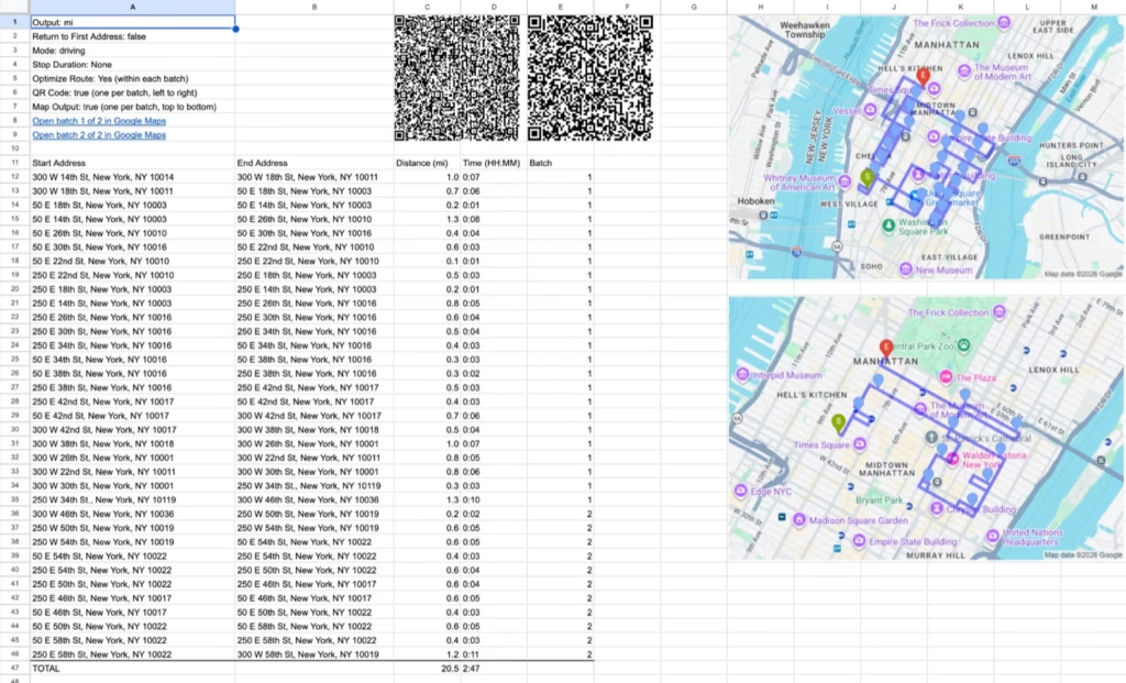
What you get: one tab for the whole route
- One table with the start and end address, the distance and the time of every leg, and a Batch column that says which batch each leg belongs to.
- One total for the whole route, at the bottom of the table.
- An Open Route in Google Maps link for each batch. Batch 2 starts at the last stop of batch 1.
- A QR code and a map image for each batch, if you ticked them.
A 36-stop list, for example, runs as two batches: the first covers stops 1 to 25, and the second starts at stop 25 and covers the rest.
Get a better route out of a long list
- Sort the list by area first. Batches follow the order of your list, so sorting by ZIP code or neighborhood makes each batch a compact cluster instead of a zigzag across town.
- Use Optimize Stop Order for the order inside each batch. It finds the quickest path through a batch’s stops. It does not move a stop from one batch to another, which is why sorting first matters. The first and last stop of a batch stay where they are.
- Tick Return to First Address if the route ends back where it started.
- Drive it batch by batch. Each batch’s Google Maps link and QR code opens that batch only. Open batch 1, drive it, then open batch 2.
Limits and plans
- Free: routes of up to 10 stops, with the distance and time of every leg and a Google Maps link.
- Premium ($93 a year, or $9 a month): up to 100 stops in one run, plus optimized stop order, QR codes, map images and stop durations. A free 7-day trial can be started from inside the add-on.
- Google’s daily limit still applies. Every route you plan counts toward the Maps limit on your Google account: 1,000 requests a day on a standard account and 10,000 on a paid Google Workspace account.
Over 100 stops? Split the sheet into two runs. RouteTally stops at 100 so that a whole column selected by mistake is not sent to Google.
Frequently asked questions
What is the most stops I can plan in one run?
On Premium, 100 stops in one run, planned in batches of up to 25. On the free plan, 10.
Does it find the best order for the whole route?
Not across batches. Optimize Stop Order works inside each batch of 25, and the batches stay in the order of your list. Sort the list by area first for the best result.
Can I drive a long route from my phone?
Yes. With a Premium subscription, every batch gets its own QR code. Scan the first one to start, and scan the next when you reach the end of the batch.
Do I need a Google Maps API key?
No. RouteTally works as soon as you install it. There is no Google Cloud account or key to set up.
Can I use public transit?
Only for a route with a start and a destination. Google does not plan transit routes with stops in between, so long routes use Driving, Walking or Bicycling.
Related tools
RouteTally plans one route through many stops. For other jobs:
- Route Matrix compares every start with every end, to choose the best hub or warehouse.
- TripTally calculates the distance and time for a long list of start and end pairs, such as a mileage log.
- Travel Formulas puts distance and travel time straight into a cell with a formula.
- Our guide to optimizing delivery routes in Google Sheets.
- Our guide to calculating the total distance and time for a list of addresses.
Ready to try it? The first 10 stops are free. See the features and plans.